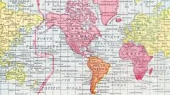
What different world maps get right - and what they get wrong
But critics of the Mercator map say there is a psychological effect to viewing some places as smaller than they actually are and others as larger, as we instinctively view bigger things as more important.
To keep those angles correct on a flat map, Mercator had to stretch the grid lines wider as they moved away from the equator toward the poles.
His map accommodates for the curvature of the Earth by making countries near the equator seem much smaller than they are, with countries nearer the poles appearing stretched.
This is a summary of the original articles listed below. Always read the source articles for the full context. GhanaSummary does not create or modify the news — we summarise and link to original publishers.